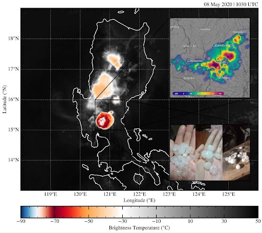
The largest hailstones ever recorded in the Philippines fell in Cabiao, Nueva Ecija, on May 8, 2020. An infrared image from the HIMAWARI-8 weather satellite taken at the time shows the convective system associated with this hail event. The inset panel on the upper right shows the corresponding radar reflectivity scan suggesting high amounts of precipitation in the area. In the lower right are photos of hailstones recovered from the event. SOURCE: Ibañez et al., 2025
MANILA, PHILIPPINES [TAC] – The Philippines, like other tropical countries, is known more for its balmy climate than for hailstorms. But a new study—the first of its kind—has found that the country’s hottest days are, in fact, more likely to produce hail.
Hailstorms are so few and far between in the Philippines that, even in an age of pervasive social media updates, they are still met with amazement and astonishment.
“Most people are surprised when hail happens because it is relatively rare in the Philippines,” said Dr. Lyndon Mark Olaguera, senior author of the study.
“Many take photos or videos and share them online. Some are scared since it’s unusual, while others just treat it as a strange kind of rain. People usually explain it as part of strong thunderstorms, and some interpret hail as a warning or sign of climate change,” Olaguera said.
The researchers found that hail events were most frequent during the dry-season months of March, April and May—precisely the period when surface temperatures peak and the atmosphere is primed for thunderstorms. Most hailstorms were found to have occurred during the mid to late afternoon, the hottest part of the day.
The counterintuitive connection between heat near the ground and ice falling from the sky is partly explained by a meteorological factor known as Convective Available Potential Energy (CAPE), a measure of how much energy is available to fuel rising air.
High CAPE values indicate conditions favorable for convective activity, wherein hot air near the Earth’s surface rapidly rises and carries moisture into towering thunderclouds. Within these clouds, powerful updrafts can carry water droplets high enough into much colder layers of the atmosphere, where they freeze and eventually turn into hailstones.
Also, the presence of dry air in the mid-troposphere can actually increase the likelihood of hailstones surviving to reach the ground. Dry air enhances evaporative cooling which strengthens downdrafts and accelerates the descent of hail. Because the hailstones spend less time passing through warmer air on their way down, they are less likely to melt completely before hitting the ground.
Spanning nearly two decades of data, from 2006 to 2024, the researchers relied on a wide range of sources—instrument data, local government records, news media and geotagged social media posts.
This multi-source, crowd-informed approach proved especially valuable given the country’s sparse ground-based hail detection capabilities. It also showed the invaluability of citizen science and public reporting in monitoring hailstorms and other severe weather hazards.
As climate change increases the likelihood of extreme weather, empowering the public to participate in data gathering may prove essential for the development of early warning systems in the Philippines.
Looking ahead, the researchers stressed the need to expand the country’s weather monitoring and forecasting capabilities. They recommend that local disaster preparedness focus not only on typhoons and floods, but also on less familiar hazards which can catch communities off guard—such as tornadoes and waterspouts, as well as hailstorms.